AIS helps us avoid the cruising sailors greatest danger - a collision at sea. Of course the system isn't perfect, however it is a powerful ally in collision avoidance and I wouldn't want to be without it. Our previous two stories (read them here and here) introduced the system and discussed a typical cruising boat installation - in this story we share our operational experiences.
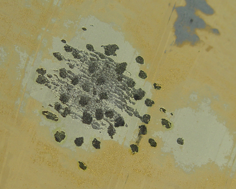
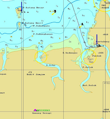 The Singapore Straits is the busiest shipping lane in the world, and the nearby Malacca Straits are not far behind in the traffic stakes. These two waterways provided a strenuous testing ground for our new Comar AIS installation. Our very first test was conducted on a three day passage from Sarawak (northern Borneo) to Singapore. Departing Kuching, capital of Sarawak, we tracked several ships on screen that were well over our visual (and radar) horizon. We also noted a fixed AIS base station on a mountain top near Kuching, reporting itself as being highly accurate in its position. As a newcomer to AIS this puzzled me, however we could see that base station for over 100 nautical miles into the Sth China Sea, so it was a welcome reference. You can see it in this image, the purple dot near the bottom, with its own MMSI number of course.
Travelling from Borneo to Singapore there are not a lot of ships - hence not a lot of AIS traffic and therefore a great signal to noise ratio. In that low noise / low traffic environment our system was receiving and plotting ship locations more than 120 nautical miles away. It was great to know well in advance the traffic that was likely to cross our path. We also noted that military support vessels don't have to run their transponder all the time - we passed within 1/4 mile of a small fleet oiler that didn't exist on AIS - though I'm pretty sure they knew where we were, and we had her on radar for hours. Whilst military vessels have a nominated identity in the AIS world, they don't always broadcast their location, for obvious reasons.
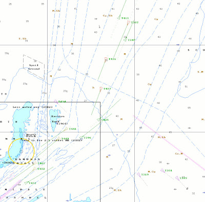 As we approached Singapore the traffic density (and target numbers) increased, and the maximum receiving range fell off. This is a logical consequence of the increased traffic levels, and illustrates how good the system really is - when traffic is dense the closer vessels dominate - which is exactly what we want for effective collision avoidance. In this image you can see vessels arriving and departing the Straits (red & green triangles) plus anchored vessels (purple triangles).
Departing Singapore for Langkawi, we cleared immigration at the Western Quarantine Anchorage. Already we had hundreds of vessels showing on our display, but the software handled things well and it was never confusing - at all times the closest and most threatening targets were clearly visible. In a dense traffic situation (harbour / river / channel) it pays to zoom in close on the chart plotter display screen, so that only local targets are visible - the ones that matter. One hour out we plotted a Class B transponder, the first we'd seen on screen, and watched this small motor vessel cross two shipping lanes and then run past our port side. Despite several hundred Class A transponders broadcasting close by, the Class B vessel was consistently visible. The 30 second reporting frequency of Class B systems was just evident - this was a quick motor boat, and the Class B position updates were just a little lumpy.
Moving into Malaysian waters we headed north west up the Malacca Straits, estimating three days for our passage to Langkawi. This was our sixth transit of the Malacca Straits, but our first with AIS, and what a great difference it makes. Every large commercial vessel showed up on our chart plotter, giving us very early warning of their speed and course. We habitually stick to the eastern edge of the main shipping channel in the straits, hoping to keep out of the ships way and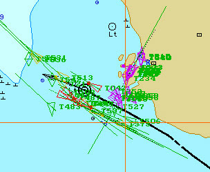 also to avoid the fish nets and fish traps that pepper the inshore waters. Passing Port Klang has always been a challenge - it's a major shipping port and many ships turn into and out of the Straits channel, but this time it was easy. This image, zoomed out on the chart display, shows the traffic density - we're the black circle and arrow in the middle. Seriously, the traffic just parted for us - ships running up the straits turned early or late and always gave us plenty of sea room - it was very clear that our AIS transmissions were being watched. What a joy. We usually keep a dual lookout in that region, one of us on port and the other on starboard, however this time it simply wasn't necessary - I slept soundly for that part of the passage. Amazingly, in that three day transit the AIS system logged over 2000 targets. That's a lot of ships.
 I've always found that most commercial mariners will try to be cooperative if they have the right information - AIS certainly gives them that. More importantly, on most large vessels the voyage data recorder (info here), like the one at left, will securely record your yacht's transmissions - no one can deny your existence. This has to encourage larger vessels to comply with SOLAS rules. The recording of AIS targets is very useful - should your tiny sailboat go missing one day, every big ship that you've passed will have a time and date stamped record of your past position to assist the search authorities. Furthermore, many shore based AIS stations (and there are thousands already in place) will see you as you pass within range and report your position - check it out here.
In my last story I mentioned that the AIS transponder provided a GPS position output in standard NMEA format. It is tempting to think of this as a useful backup to our primary GPS receivers, but think again. It seems that the AIS GPS positions are often fine tuned with differential information broadcast by local AIS base stations (hence that "high accuracy" base station we observed in Borneo). Also, AIS GPS hardware is built to far more stringent standards (IEC61108) than conventional receivers. This means that your AIS GPS system is most likely more accurate than your existing primary GPS in many coastal situations - so you should use the AIS position data as a first preference !
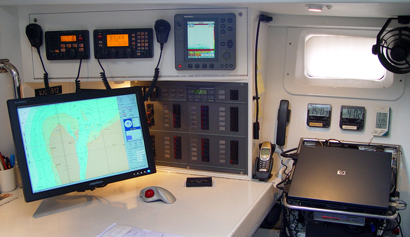
On Crystal Blues our AIS data is received and displayed by our PC based chart plotting software - Transas Navigator Pro. The software displays our vessel, plus all the AIS & MARPA radar targets, as live moving indicators overlaid onto the electronic chart. This is an incredibly powerful tool, derived from commercial shipping software.
AIS is in its infancy, but it clearly has a future on your boat. Thousands of aids to navigation already carry AIS transponders, so that you can see them even when the weather is thick. Some are suggesting that "virtual aids" will soon appear on your AIS display - electronic marker buoys that can be placed rapidly if a new wreck or other danger appears. These can be activated almost instantly by maritime authorities, well before a real buoy can be positioned. And in a distress situation, any commercial vessel can accurately locate Crystal Blues with ease, once within range.
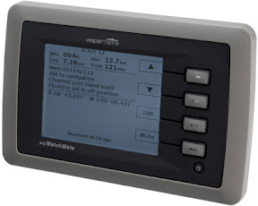 This week I received an email from Jeff Robbins, developer of the highly rated Vesper Marine Watchmate AIS display. The Watchmate is a very simple (low power) LCD screen that interprets data from any AIS unit and displays it essentially the way you need it. To quote Jeff "Watchmate prioritises targets ... the most important collision risks appear first. It also filters the data to eliminate false alarms when operating in harbour or crowded situations. And it has a user selectable "profile", that allows the user to select with a single button their sailing situation (eg. anchored, harbour,coastal,offshore)..."
Phew - Jeff has done his homework, and his display screen seems probably the best way to handle AIS information if you don't already have a compatible chart plotting system, and a very smart way to go even if you do. Of course it works with transponders or simple receivers.
Whilst we don't have Jeff's screen we're pleased with the extra safety and navigational information we receive from our AIS sytem, and even more pleased that the big boats out there know exactly where we are, day and night - rain, hail or shine. AIS transponders are a great advance in safety for both coastal and ocean sailors. Cruising author and boat designer Steve Dashew says of AIS "I would put an AIS B way ahead of most other “necessities” for a cruising yacht, especially when cruising in areas with lots of rain".
 The Singapore Straits is the busiest shipping lane in the world, and the nearby Malacca Straits are not far behind in the traffic stakes. These two waterways provided a strenuous testing ground for our new Comar AIS installation. Our very first test was conducted on a three day passage from Sarawak (northern Borneo) to Singapore. Departing Kuching, capital of Sarawak, we tracked several ships on screen that were well over our visual (and radar) horizon. We also noted a fixed AIS base station on a mountain top near Kuching, reporting itself as being highly accurate in its position. As a newcomer to AIS this puzzled me, however we could see that base station for over 100 nautical miles into the Sth China Sea, so it was a welcome reference. You can see it in this image, the purple dot near the bottom, with its own MMSI number of course.
Travelling from Borneo to Singapore there are not a lot of ships - hence not a lot of AIS traffic and therefore a great signal to noise ratio. In that low noise / low traffic environment our system was receiving and plotting ship locations more than 120 nautical miles away. It was great to know well in advance the traffic that was likely to cross our path. We also noted that military support vessels don't have to run their transponder all the time - we passed within 1/4 mile of a small fleet oiler that didn't exist on AIS - though I'm pretty sure they knew where we were, and we had her on radar for hours. Whilst military vessels have a nominated identity in the AIS world, they don't always broadcast their location, for obvious reasons.
 As we approached Singapore the traffic density (and target numbers) increased, and the maximum receiving range fell off. This is a logical consequence of the increased traffic levels, and illustrates how good the system really is - when traffic is dense the closer vessels dominate - which is exactly what we want for effective collision avoidance. In this image you can see vessels arriving and departing the Straits (red & green triangles) plus anchored vessels (purple triangles).
Departing Singapore for Langkawi, we cleared immigration at the Western Quarantine Anchorage. Already we had hundreds of vessels showing on our display, but the software handled things well and it was never confusing - at all times the closest and most threatening targets were clearly visible. In a dense traffic situation (harbour / river / channel) it pays to zoom in close on the chart plotter display screen, so that only local targets are visible - the ones that matter. One hour out we plotted a Class B transponder, the first we'd seen on screen, and watched this small motor vessel cross two shipping lanes and then run past our port side. Despite several hundred Class A transponders broadcasting close by, the Class B vessel was consistently visible. The 30 second reporting frequency of Class B systems was just evident - this was a quick motor boat, and the Class B position updates were just a little lumpy.
Moving into Malaysian waters we headed north west up the Malacca Straits, estimating three days for our passage to Langkawi. This was our sixth transit of the Malacca Straits, but our first with AIS, and what a great difference it makes. Every large commercial vessel showed up on our chart plotter, giving us very early warning of their speed and course. We habitually stick to the eastern edge of the main shipping channel in the straits, hoping to keep out of the ships way and
 also to avoid the fish nets and fish traps that pepper the inshore waters. Passing Port Klang has always been a challenge - it's a major shipping port and many ships turn into and out of the Straits channel, but this time it was easy. This image, zoomed out on the chart display, shows the traffic density - we're the black circle and arrow in the middle. Seriously, the traffic just parted for us - ships running up the straits turned early or late and always gave us plenty of sea room - it was very clear that our AIS transmissions were being watched. What a joy. We usually keep a dual lookout in that region, one of us on port and the other on starboard, however this time it simply wasn't necessary - I slept soundly for that part of the passage. Amazingly, in that three day transit the AIS system logged over 2000 targets. That's a lot of ships.
In my last story I mentioned that the AIS transponder provided a GPS position output in standard NMEA format. It is tempting to think of this as a useful backup to our primary GPS receivers, but think again. It seems that the AIS GPS positions are often fine tuned with differential information broadcast by local AIS base stations (hence that "high accuracy" base station we observed in Borneo). Also, AIS GPS hardware is built to far more stringent standards (IEC61108) than conventional receivers. This means that your AIS GPS system is most likely more accurate than your existing primary GPS in many coastal situations - so you should use the AIS position data as a first preference !
On Crystal Blues our AIS data is received and displayed by our PC based chart plotting software - Transas Navigator Pro. The software displays our vessel, plus all the AIS & MARPA radar targets, as live moving indicators overlaid onto the electronic chart. This is an incredibly powerful tool, derived from commercial shipping software.
AIS is in its infancy, but it clearly has a future on your boat. Thousands of aids to navigation already carry AIS transponders, so that you can see them even when the weather is thick. Some are suggesting that "virtual aids" will soon appear on your AIS display - electronic marker buoys that can be placed rapidly if a new wreck or other danger appears. These can be activated almost instantly by maritime authorities, well before a real buoy can be positioned. And in a distress situation, any commercial vessel can accurately locate Crystal Blues with ease, once within range.
 This week I received an email from Jeff Robbins, developer of the highly rated Vesper Marine Watchmate AIS display. The Watchmate is a very simple (low power) LCD screen that interprets data from any AIS unit and displays it essentially the way you need it. To quote Jeff "Watchmate prioritises targets ... the most important collision risks appear first. It also filters the data to eliminate false alarms when operating in harbour or crowded situations. And it has a user selectable "profile", that allows the user to select with a single button their sailing situation (eg. anchored, harbour,coastal,offshore)..."
Phew - Jeff has done his homework, and his display screen seems probably the best way to handle AIS information if you don't already have a compatible chart plotting system, and a very smart way to go even if you do. Of course it works with transponders or simple receivers.
Whilst we don't have Jeff's screen we're pleased with the extra safety and navigational information we receive from our AIS sytem, and even more pleased that the big boats out there know exactly where we are, day and night - rain, hail or shine. AIS transponders are a great advance in safety for both coastal and ocean sailors. Cruising author and boat designer Steve Dashew says of AIS "I would put an AIS B way ahead of most other “necessities” for a cruising yacht, especially when cruising in areas with lots of rain".